Hurricane Hugo: 37 Years Ago Tonight, the Ocean Hit Myrtle Beach
Charleston gets most of the historical spotlight. Fair enough. Hugo came ashore near Sullivan’s Island as a powerful Category 4 hurricane, and the Charleston area absorbed a direct hit from the storm’s worst winds.
Category: local | Published: 2026-09-22
Hurricane Hugo: 37 Years Ago Tonight, the Ocean Hit Myrtle Beach
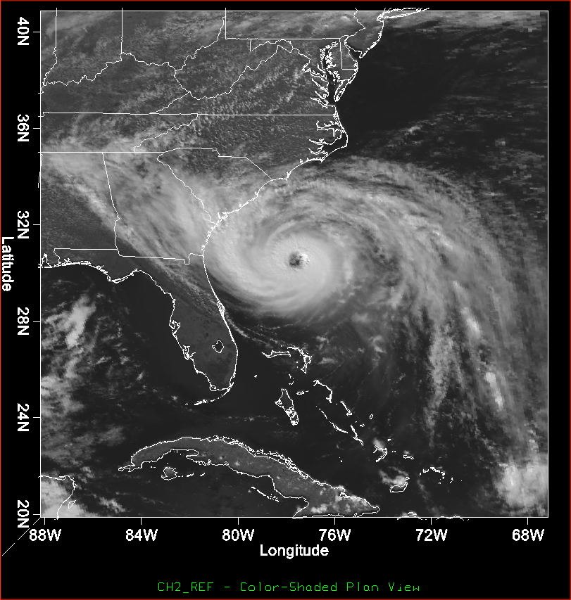
Credit: NOAA / National Weather Service — satellite image of Hurricane Hugo approaching the Carolinas, September 21, 1989.
Tonight, 37 years ago, Hurricane Hugo crossed the South Carolina coast.
Charleston gets most of the historical spotlight. Fair enough. Hugo came ashore near Sullivan’s Island as a powerful Category 4 hurricane, and the Charleston area absorbed a direct hit from the storm’s worst winds.
But Myrtle Beach has its own Hugo story.
It is not mainly about wind.
It is about water.
That distinction matters. The Grand Strand did not record Charleston’s 108-mph gust downtown or the extreme wind readings from ships and military stations closer to the eye. Myrtle Beach’s official peak gust was 76 mph.
What the coast did receive was a 13-foot storm surge. The highest ever measured in Myrtle Beach history.
That is the part of the story easy to miss when Hugo gets reduced to one landfall point, one famous photograph, or one set of Charleston damage numbers. The storm’s eye stayed south. Its ocean did not.
The Basics
Hugo made landfall around midnight, straddling September 21 into September 22, 1989, near Sullivan’s Island just north of Charleston. At landfall, it was a Category 4 hurricane with maximum sustained winds near 140 mph and a central pressure of 935 millibars.
Myrtle Beach sat roughly 80–90 miles north of the eye: far enough away to avoid the most violent winds, but not far enough to escape the surge pushed northward along the coast.
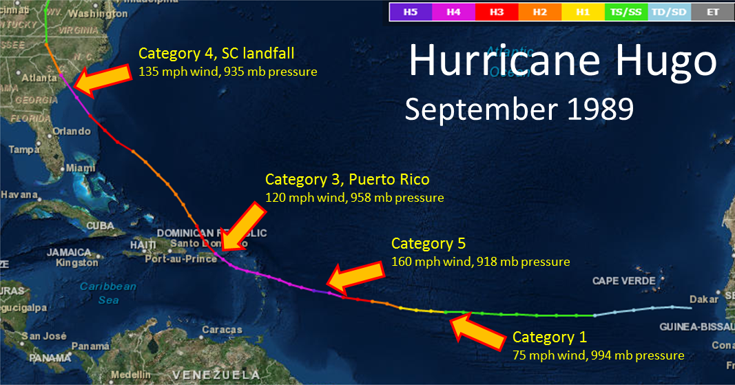
Credit: NOAA / National Weather Service, Hurricane Hugo track map, September 1989.
Before Hugo reached South Carolina, it had already crossed a remarkable stretch of the Atlantic and Caribbean.
The storm formed from a tropical disturbance off the coast of Africa on September 9, 1989. It strengthened quickly over warm Atlantic water, reaching Category 5 intensity on September 15 with maximum sustained winds of 160 mph and a central pressure of 918 millibars.
That pressure reading placed Hugo among the most intense Atlantic hurricanes ever recorded.
The storm later weakened while crossing Guadeloupe, Montserrat, the U.S. Virgin Islands, and Puerto Rico. Hugo’s eye crossed St. Croix early on September 18, then moved across Vieques and Puerto Rico near Fajardo about six hours later. The high terrain of Puerto Rico took some of the storm’s strength out of it.
But Hugo was not finished.
As it moved back over the warm waters of the western Atlantic and Gulf Stream, the hurricane reorganized. A clear eye returned. Pressure fell. Winds increased. By the time Hugo approached the Carolinas on September 21, it had re-strengthened into a Category 4 hurricane.
Its forward speed also became part of the danger. Hugo was moving quickly, which helped carry hurricane-force winds far inland after landfall. The storm’s damaging wind field stretched roughly 50 miles wide and 200 miles long. Seven hours after landfall, hurricane-force winds were still being recorded as far inland as the North Carolina Piedmont and foothills.
In 1989, forecasters were working with analog WSR-57 and WSR-74 radar systems. These were not the modern Doppler radars familiar to anyone watching a current tropical system. The older equipment could show precipitation structure and the hurricane’s eye, but it could not measure wind velocity in the atmosphere the way today’s Doppler network can.
There were no polished phone alerts arriving every few minutes. No live storm-surge graphics on a weather app. No color-coded evacuation-zone map in everyone’s pocket.
Forecasting relied on satellite imagery, aircraft reconnaissance, conventional radar, surface observations, telephone coordination, radio, and the judgment of forecasters and emergency managers working with much less data than today.
That makes Hugo’s track forecasts and evacuation effort even more notable, and it also explains why the storm’s inland wind threat surprised so many people.
Myrtle Beach Didn’t Get Hugo’s Wind. It Got Hugo’s Ocean.
Here is the local headline, without the tourist-brochure polish:
Myrtle Beach’s wind numbers were modest for a storm of Hugo’s size. Its water numbers were historic.
At Myrtle Beach Air Force Base, Hugo produced:
- A peak wind gust of 76 mph
- Maximum sustained winds of 52 mph
- A lowest recorded pressure of 993.5 millibars
- 2.3 inches of rainfall
- A 13-foot storm surge
That 13-foot surge remains the highest ever measured in Myrtle Beach history.
The storm did not need to place the eye over the Grand Strand to do that kind of damage. Hugo’s size, speed, angle of approach, coastal geography, and the timing of the tide all worked together. Water moved inland while the storm’s strongest winds remained concentrated farther south.
Myrtle Beach vs. Charleston: Same Storm, Different Story
| Measurement | Myrtle Beach | Charleston downtown |
|---|---|---|
| Peak wind gust | 76 mph | 108 mph |
| Maximum sustained wind | 52 mph | 87 mph |
| Lowest recorded pressure | 993.5 mb | 938.7 mb |
| Rainfall | 2.3 inches | 6.37 inches |
| Storm surge or storm tide | 13 feet | 8 feet |
The stations were not identical, and measurements varied across the region. Charleston Harbor recorded even higher readings, including a 138-mph gust from a ship. The ship Snow Goose, anchored in the Sampit River near Georgetown, recorded sustained winds of 120 mph.
But the comparison still tells the story.
Charleston took the punch from the wind.
Myrtle Beach took a historic shove from the Atlantic.
Farther south and closer to landfall, Bulls Bay saw a storm surge of approximately 20 feet. That remains the highest storm surge ever recorded on the U.S. East Coast.
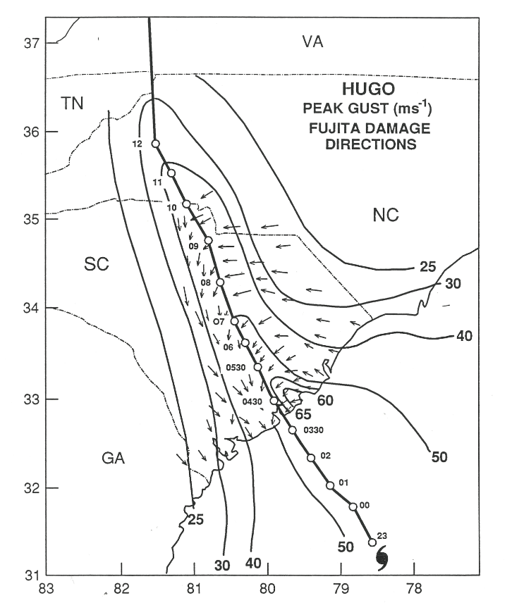
Credit: NOAA / National Weather Service, Hurricane Hugo wind swath and peak-gust damage-direction map.
The water was not simply a wave rolling onto the beach and then politely retreating. Surge pushed across low-lying neighborhoods, roads, dunes, hotels, homes, marinas, and beach infrastructure.
That is the uncomfortable coastal truth Hugo left behind: a storm can miss Myrtle Beach’s bull’s-eye and still remake the shoreline.
The Grand Strand, South to North
Hugo’s damage along the coast was not evenly distributed. Communities only a few miles apart experienced different combinations of surge, wave action, wind exposure, dune loss, and flooding.
Pawleys Island
Pawleys Island was cut clean in two.
The surge carved a new inlet through the island, separating sections of shoreline that had previously been connected. Around 14 homes were destroyed outright, and three were carried away by the water and deposited in the tidal creek behind the island.
For a place shaped by shifting sand, marsh, tides, and inlets, this was not simply a bad beach day. Hugo temporarily redrew the map.
The new opening became one of the clearest examples of how quickly a barrier island can change when storm water finds a weak point. The island’s shape, dune system, and nearby tidal channels all influenced where the water went.
Garden City
Garden City took some of the most severe damage along the Grand Strand.
The storm surge wiped out up to 90% of homes, undermined beachfront hotels and condominiums, and destroyed the city’s pier. Sand was pushed three blocks inland. Evidence of seawater flooding and damage extended as far as 1,500 feet from the water’s edge.
Horry County administrator M. L. Love summed up the devastation in a sentence that has lasted nearly four decades:
“Garden City for all practical purposes is gone.”
That line is blunt, but it captures what photographs and statistics sometimes cannot. A community can remain on the map while its familiar buildings, roads, piers, dunes, and landmarks disappear in a single night.
Surfside Beach
Surfside Beach also saw major surge damage.
Sand and mud covered Ocean Boulevard to a depth of approximately 10 inches, mixed with tree limbs and building debris. The Surfside Fishing Pier was destroyed, and the surge was estimated at 13 feet above sea level.
For locals, the pier losses were more than a footnote. The Grand Strand’s piers have long served as visual anchors: part fishing platform, part landmark, part unofficial measurement stick for how much the beach has changed.
When several piers disappeared during Hugo, the damage became impossible to ignore.
Myrtle Beach
Myrtle Beach’s beachfront hotels and homes were heavily damaged. The bulk of the protective dunes was washed away, leaving the developed shoreline more exposed to the next storm.
Springmaid Pier was reduced to only 150 feet of its former length. Two other Myrtle Beach piers were destroyed by the combined force of storm surge and large crashing waves.
Roughly 150 wooden beach-access walkways were wiped out.
Ocean Boulevard was covered by sand and standing water. In sections of the northern Grand Strand, reports described several feet of water over the boulevard.
Today, it is easy to look at the developed coastline and assume the beach has always been this engineered, reinforced, and constantly rebuilt. Hugo showed what happens when the natural buffer is stripped away and the ocean gets a clear run at the built environment.
The storm did not need to knock every building flat to leave a permanent mark. Losing dunes, walkways, piers, roads, and beach width changed the relationship between the community and the water.
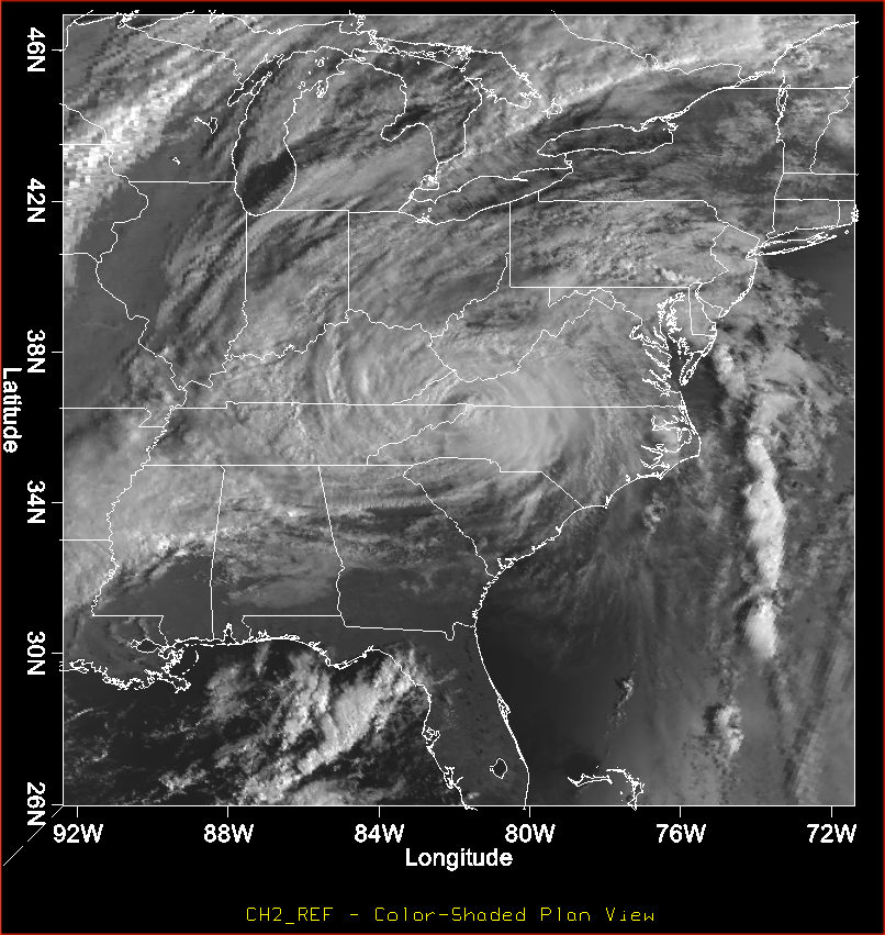
Credit: NOAA / National Weather Service, Visible satellite image of Hurricane Hugo, September 22, 1989.
The McClellanville Warning
South of Myrtle Beach, McClellanville became the storm’s most sobering safety lesson.
Lincoln High School had been designated as a hurricane shelter because evacuation maps listed the school at roughly 20 feet of elevation. That was considered safe ground.
The actual elevation was closer to 10 feet.
Hugo’s surge outside the school reached roughly 16 feet. Water broke into the building and rose to approximately six feet inside the gymnasium and cafeteria. More than a thousand evacuees were trapped inside and had to climb onto tables, bleachers, and rafters to escape the rising water. Children were lifted toward the rafters as the water continued to rise.
No one died there.
That outcome was fortunate, but it did not make the failure less serious. A shelter that appeared safe on paper was not safe against the storm that arrived.
Hugo exposed the consequences of bad elevation information. Evacuation routes and shelters are only as reliable as the maps behind them. After the storm, the school’s elevation error became part of the national disaster survey and a warning to emergency planners everywhere.
🧭 The lesson is straightforward: a designated shelter is not automatically a safe shelter. Elevation, structural strength, access routes, flood exposure, and storm intensity all matter.
McClellanville also showed how surge can become more dangerous than wind. People who had evacuated toward what they believed was higher ground found themselves trapped by water inside a public building. In a hurricane, “away from the beach” is not the same thing as “out of danger.”
Recovery and the Policy Aftermath
South Carolina deployed about 1,300 National Guardsmen after Hugo. Dusk-to-dawn curfews were imposed, and public warnings were issued against looting as communities dealt with widespread damage, blocked roads, power failures, and disrupted communications.
Along the Grand Strand, an estimated 79% of residents evacuated ahead of the storm. Only 13% went to official public shelters. Most stayed with relatives, checked into motels, or moved inland through personal networks.
That detail says something about how evacuation actually works. It is not always a neat line of cars heading to a government shelter. Many people leave early because a friend has a spare room, a relative lives inland, or a motel becomes the most practical option.
Hugo also damaged roughly 4.5 million acres of South Carolina forest. The state lost more timber in one night than it typically harvested in three to four years combined.
The forest damage extended far beyond the coast. Hugo knocked down trees across the Midlands and into North Carolina, where communities such as Charlotte experienced destructive winds despite being far from the ocean.
At the time, Hugo was the costliest hurricane in U.S. history. It caused at least $8 to $10 billion in damage across its path and was responsible for at least 86 fatalities. Hurricane Andrew surpassed Hugo’s U.S. cost record in 1992.
The storm also became a major test of South Carolina’s 1988 Beachfront Management Act.
Post-storm surveys found a clear difference between structures supported by deep pile foundations and older buildings sitting on shallow spread footings. Deep foundations generally performed better. Shallow foundations were vulnerable when surge and waves scoured away the sand underneath them.
That is the part of Hugo still visible in the way the coast was rebuilt. Building codes, foundation standards, dune policy, setbacks, and beach-management rules became more than technical language in a planning document. They became questions about whether a building could remain standing after the sand around it disappeared.
Economic pressure soon complicated that policy response. Within a year, lawmakers loosened some of the Act’s no-build setback rules.
That tension is familiar along the coast. Storms reveal the risks. Rebuilding creates pressure. Property values and public safety end up in the same meeting room, usually with nobody leaving completely satisfied.
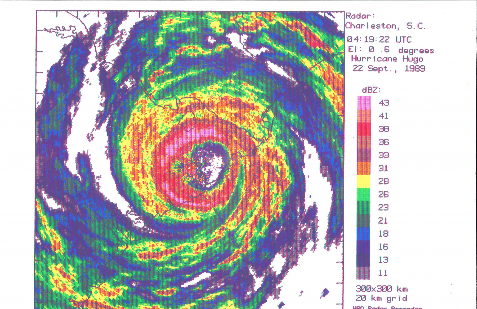
Credit: NOAA / National Weather Service, Charleston WSR-57 radar image of Hurricane Hugo’s eye at 12:19 a.m. EDT on September 22, 1989; NOAA/AOML/Hurricane Research Division.
Why It Still Matters Tonight
Hugo is a reminder that a hurricane’s eye does not have to come near Myrtle Beach to change Myrtle Beach.
The wind stayed south.
The water did not.
Thirty-seven years later, the 13-foot surge record remains the benchmark for Myrtle Beach. It is the number local emergency planners and coastal researchers return to when discussing the Grand Strand’s worst-case storm scenarios.
The record is also a useful correction to the way hurricane risk gets discussed. Wind speed tends to dominate the conversation because it is easy to understand. A 140-mph hurricane sounds terrifying, and it is.
But water is often the more persistent threat.
Water undermines roads. It removes dunes. It enters homes and hotels from below. It pushes sand across highways, fills streets, damages utilities, destroys piers, and changes inlets. It can travel inland while the wind measurements at the nearest airport look comparatively ordinary.
That is why a 76-mph gust does not tell the full Myrtle Beach story.
Hugo was not the last major storm to test the Grand Strand, and it will not be the last. The shoreline has been rebuilt, reshaped, nourished, hardened, and developed since 1989. Some older structures are gone. Newer structures stand where Hugo erased what came before.
The beach looks familiar. The risk is still there.
For those who lived here, Hugo may be remembered through a particular sound: chainsaws after sunrise, water against a door, debris striking a window, generators starting up, or the long silence after the power went out.
Some remember leaving. Some remember staying. Some remember seeing the ocean where the road had been.
Where were you when Hugo came through, and which storm do you consider the real benchmark for the Grand Strand?
More from Myrtle Beach Unlocked
- Myrtle Beach Beaches Guide
- Current Beach Conditions
- Every Storm That Ever Wrecked This Place
- Weather & Tides
Official sources
https://www.weather.gov/ilm/hurricanehugo
https://www.nhc.noaa.gov/outreach/history/
https://www.weather.gov/media/ilm/climate/Hugo/Natural%20Disaster%20Survey%20Report%20Hugo.pdf
https://www.weather.gov/media/ilm/climate/Hugo/NHC_report_Hugo.pdf
https://dnr.sc.gov/hugo/gallery.html
http://www.gcdigital.org/cdm/search/collection/p15077coll6
https://scholarcommons.sc.edu/cgi/viewcontent.cgi?article=3162&context=sclr